


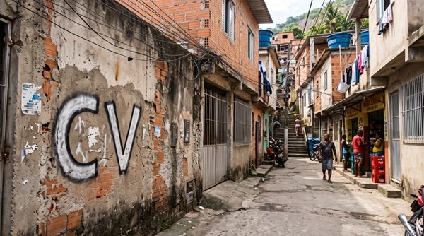
On Wednesday, November 11, 2026, the Institute of Public Security (ISP) released the first public mapping of territorial operations by criminal factions and paramilitary militias across the state of Rio de Janeiro. Conducted in 2025, the survey identified 1,530 distinct areas inhabited by over 5.1 million people, representing approximately 32% of the state’s population. Collectively, these territories span 614.3 km², or 1.4% of the state’s landmass, and are heavily concentrated in the capital and the Greater Rio Metropolitan Area, including the Baixada Fluminense region. Population estimates utilize data from the 2022 Census conducted by the Brazilian Institute of Geography and Statistics (IBGE) as a baseline.
This Content Is Only For Subscribers
To unlock this content, subscribe to INTERLIRA Reports.
Comando Vermelho Predominates in Half of Mapped Territories
The Red Command (Comando Vermelho – CV) was identified as the dominant criminal group in 779 areas, or 50.9% of the total, affecting nearly 3 million residents. Paramilitary militias rank second, dominating 300 areas (19.6%) with roughly 917,000 inhabitants, followed by the Pure Third Command (Terceiro Comando Puro – TCP) in 274 areas (17.9%) with approximately 915,000 residents. Amigos dos Amigos (ADA) held predominance in 91 areas (5.9%), covering around 222,000 people. Among the territories attributed to the CV in 2025, 84 had been controlled by rival groups in the 2019 assessment: 39 were previously linked to militias, 24 to the TCP, and 21 to the ADA. This shift highlights areas where dominant territorial control changed hands between the two survey cycles.
How the ISP Delimited Operational Territories
The mapping initiative began in 2016 using intelligence gathered by operational planning units within Military Police battalions. The dataset was revised in 2019 with input from specialized Civil Police precincts and the Rio de Janeiro State Public Prosecutor’s Office (MPRJ). For the 2025 edition, the ISP integrated records from Operation Zero Barricade (Operação Barricada Zero), field observations, and aerial intelligence collected via drone overflights. Territorial boundaries were defined using physical and operational indicators, including the presence of street barricades, armed patrols, gunfire reports, stolen cargo transshipment hubs, and restrictions imposed on state agents. The methodology encompasses informal settlements (favelas), public housing complexes, urbanized thoroughfares, and specific commercial or residential properties. Under the ISP’s operational definition, territorial presence includes the regular movement of faction members and the execution of illicit activities, even where a group exercises only partial control. While the 2019 mapping identified 868 territories, the institute notes that expanded intelligence sources and refined mapping methodologies in 2025 prevent the numerical increase from being interpreted as a direct measurement of organized crime’s territorial expansion.
Analysis
For corporate organizations operating in Rio de Janeiro, the ISP survey serves as a foundational baseline for identifying where personnel, physical assets, and logistics corridors face heightened exposure to mobility restrictions. Risk assessments must evaluate entire transit networks, including facility access points, employee embarkation zones, and secondary arteries used by third-party service providers, as a localized roadblock or territorial dispute can disrupt supply chains far beyond the immediate exclusion zone.
Because the map reflects baseline conditions recorded in 2025, day-to-day operational security still relies on real-time intelligence tracking dynamic road closures, armed clashes, and police operations. Cross-referencing this structural territorial mapping with live incident feeds enables security teams to establish alternate routing, adjust delivery windows, and define clear thresholds for suspending or resuming field deployments.
Sources: O Globo; G1; Extra; Folha de SP.

